Jeff's North Lexington Running Guide
May 08, 2021North Lexington is a challenging place to run. When I lived on the south side, I could turn just about any run into a loop pretty easily, even for short runs. On this side, that's often not possible because of all the obstacles. Chief among these is I-95; if you cross that, you're either coming back the same way or you're doing five-plus miles. To make that even more fun, the crossings tend to be at hills like Mass Ave to the west or Grove St to the north. Speaking of hills, they get in the way too. Good luck going over Meriam Hill without hitting a 10% grade somewhere, and Glen St is 18% at the bottom if you're really looking for a challenge. I think this is part of why the Diamond cross-country team are perennial state champions. I see them often on North St, and sometimes right outside my house since I'm near the top of Manor Hill (which I'd call Preston Hill but nobody asked me). Then there are roads that run parallel with few routes between them, the Minuteman bikeway being too crowded during a pandemic, and so on.
Without further ado, then, here are some of the routes I use to get around all this complexity.
1. Around Willard Woods
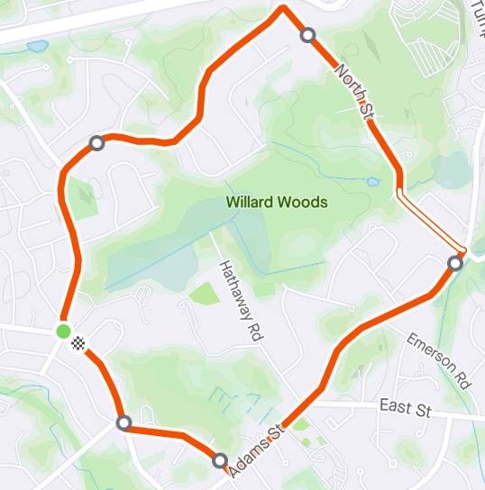
This is the one I do when I can't think of anything else, for just over 5K. From the Diamond rotary: north on Burlington, east at the Grove fork, right onto North St, right onto Adams, cut over on Coolidge, final right back onto Hancock. The nice thing about this route is that it's really about twenty routes. If you add all the "extras" you can stretch it into almost five miles with lots of hills. If you use all of the cut-throughs it can be a flat two miles. Here's one of the longer forms.
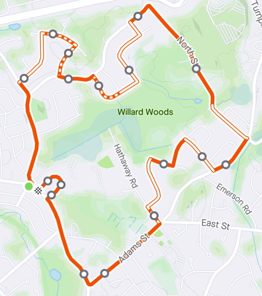
That's a lot, so here are some notes basically following the route.
- Extra #1 is taking the left fork onto Grove St instead of staying on Burlington, then Diamond St, North Emerson, and Angier back up to Burlington further on.
- Visibility on the north-west side of Burlington from just before Longfellow to just after Hawthorne is terrible because some idiots built walls there, so I highly recommend staying on the southeast side. Visibility trumps "run toward traffic" IMO. This stretch is also great for seeing turkeys in the spring and fall.
- Extra #2 is from Burlington - Longfellow, Whittier (bit of a climb from this side), and Graham. Watch out for those cul de sacs. Also, there is a very useful forest cut-through opposite Hawthorne, which can avoid North St altogether and take you straight back to extra #3 if you're so inclined. It's really hard to see from this side, so I recommend doing it the other way first.
- At the Burlington/North corner (very sharp) you can peek through the fence to I-95.
- That first part of North St from this direction is quite steep, but short. This is actually the easier direction. From the other side it's a shallower but much longer slog.
- If you really want to add distance, instead of turning immediately onto Adams you can continue along North St, then south on Lowell St and back on East St to Adams near Fiske. That part of North St is pretty awful - very sharp turn with a guardrail, poor visibility, narrow shoulder. I don't recommend it in winter. I think you can get up to 10K with variants on this route.
- Extra #3 is off Adams - Mill Brook (or Westwood), Suzanne, Brent, and Hathaway. It's a bit twisty-turny - watch for those cul de sacs again, and the other way for Suzanne looping around - but it does avoid the stretch of Adams with a railing (awkward if someone else is coming the other way). This has the other end of the cut-through to Longfellow, near the "Adams Street" pool which isn't on Adams Street. There's another cut-through on Sedge Rd to the Diamond sports fields, then around the school back to Hancock. This avoids the following hill, but I hardly ever use it myself.
- The Adams St hill opposite Fiske is annoying, and the biggest challenge on the route in this direction. I usually walk most of it TBH. You can avoid most of it by going through Chiesa Farm to Victory Garden. Also, this is by far the most crowded part of the route. Besides school children, you're also likely to encounter clots of dog walkers blocking the entire sidewalk.
- Extra #4 is to keep going up the hill on Adams instead of turning onto Coolidge, then back down and sharp right turn onto Hancock. I hardly ever feel tempted.
- Finally, extra #5 is just going around Victory Garden instead of straight on Hancock. I like to call it "Victory Lap" because of where it is on the route, and I often use it to stretch an otherwise-short run to that day's mileage goal.
2. Eastern Routes
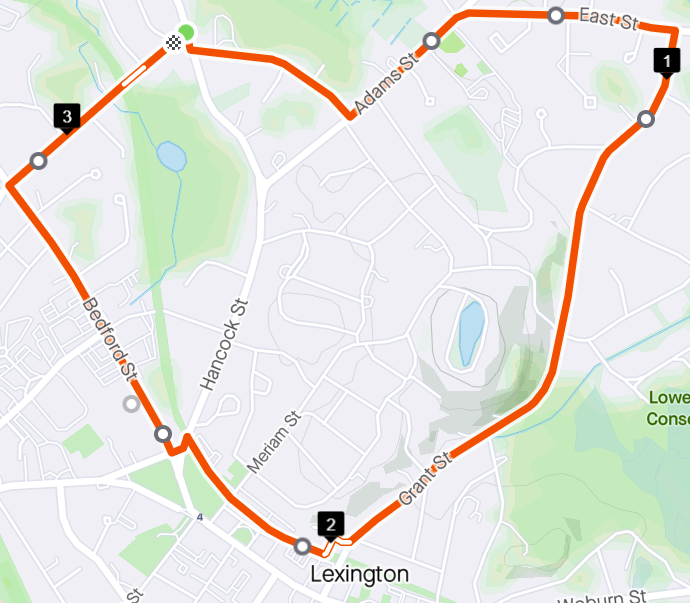
This map picks up just south of the previous ones, at the Hancock/Adams/Coolidge junction. Just like we went around Willard Woods before, this time we'll go around Meriam Hill for about the same 5K distance. Another key feature is avoiding Lexington Center. I don't like dodging around lots of pedestrians on the sidewalk. I like dodging around both parked and moving cars even less. Therefore, Mass Ave from Woburn St up to the Green is dead to me. In normal times, this isn't a big deal because I can just use the parallel part of the Minuteman bikeway instead. Unfortunately, this is the most crowded part of the bikeway in Lexington - often more crowded than the sidewalks in summer. I traverse it exactly twice each month because I've been doing segments in each direction every single month for seven years (even in winter) and I don't want to break my streak, but even then I try to do minimal sections during low-traffic periods until this pandemic is well and truly over. Notes again, following the route:
- The first part - Coolidge, Adams, East St until Grant - is utterly unremarkable. It's pleasant, but not much to say about it.
- From Grant, the challenge is to get back to the west side of the hill. If you want to go over it, your options from north to south are Colony (just over 10% maximum grade), York (just under 10%), or Glen (just under 18%). Sometimes I walk up Glen, then zig-zag west back to Hancock. You can also go north along Oakland, including one of my favorite little hidden paths just before Meriam, and get back to Adams. I'll include another picture after the notes showing these details.
- At the end of Grant, you're literally going through someone's driveway back up to the bike path. Apparently that's OK. According to maps you can go along Grant Place and hop on the path there, but somebody put up a (very likely illegal) fence there so no you can't.
- Instead of actually going on the bike path immediately (as shown but I'm too lazy to fix it) I usually avoid people by going through the parking lot up to Meriam. After that, it's either along Meriam to the Green or along the shorter bike-path section before cutting over to Bedford on the last little bit of Hancock. Can't wait until this all becomes safe again.
- That first stretch of Bedford St is frankly a bit tedious, but it's not crowded or dangerous. Be careful at Worthen/Camellia, between the fire station and Neillio's, because drivers there won't be. After that, there's a bit of a climb to Revere, and a straight shot back to the start.
Here's a zoomed-in view of Meriam Hill.
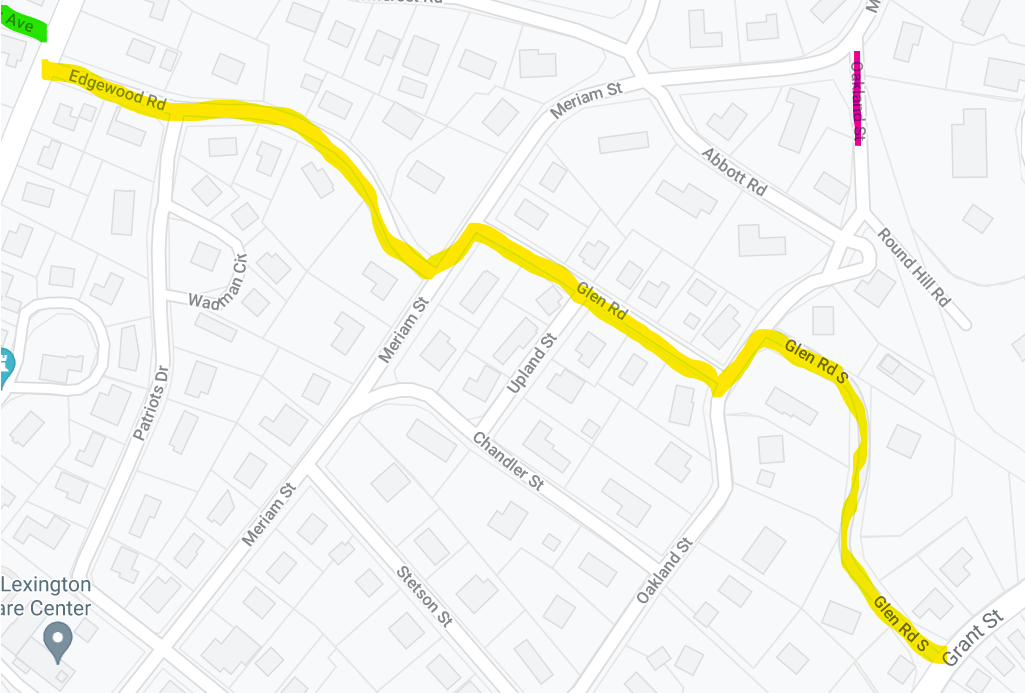
The yellow line is the Glen Rd zig-zag from Grant to Hancock. The pink line at the upper right is the little hidden dell. Note that it's a pretty good uphill north on Meriam from there to Adams, or you can turn south and rejoin the yellow line. At the top left, where "Ave" is highlighted in green, is Hancock Ave. That's a very useful little shortcut - one block, across the bike path, behind the fire station, back to Bedford St. It's a great thing to know for other routes that also use Hancock one way and Bedford the other.
3. Western Routes
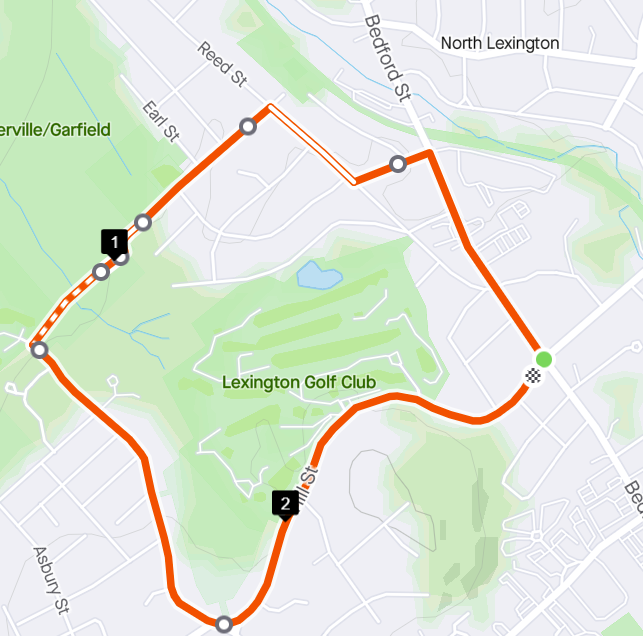
Now we're starting with our far-right corner where the far-left corner of the previous route was, at Bedford and Revere/Hill, for about 8km or 2.5 miles. Partly I wanted to include this because that first part of Bedford St is one of my absolute favorites - a steady gentle downhill, with a nice wide bike lane if I need to avoid pedestrians on the sidewalk. This is where I set a lot of my 1km best times now. Notes:
- The picture shows a cutover from Bedford St to Reed St via Sunnyknoll. You can also hop directly onto Reed St from Bedford St (just before the strip mall where Alexander's Pizza has been the only long-term survivor), cut over earlier on Vaille, or cut over later on the bike path (which I'll discuss in the next section). It looks like you can also go down Sunnyknoll Terrace and cut across the corner of a playground, but I just now discovered that and haven't tried it yet.
- Why on earth does it label tiny little Earl St but not Garfield? That's the street leading from Reed down to the "1" mile marker.
- The path through the woods from the south end of Garfield to Cedar is wonderful and convenient, but it does get mucky after even a slight rain and it's barely passable in winter.
- That last dot still seemingly in the woods is the end of Cedar St.
- I will admit that climbing out of the hole from Pine Meadows GC, up Cedar and Hill to the high point near Lexington GC, is a struggle even for hill specialists like me. If you can do it without stopping, kudos!
- Totally irrelevant to this article, but the other side of Cedar St from Hill to Mass Ave is a really good trick to know if you want to avoid multiple lights on the more obvious Worthen route.
4. Bike Path
You might be getting the impression that I hate the Minuteman bikeway. I really don't. In fact I like it quite a lot; I was thrilled when we moved to this part of town and I saw that I'd be able to use it more. What I don't like is the crowds, so I try to use it sparingly and only during low-traffic times. My favorite is a light morning drizzle, which keeps just about everyone else - especially cyclists - off it but I don't mind at all.
From this part of town, it's very easy to build a 5K going west on the bike path. For me that's out to Hartwell, but your (literal) mileage may vary. I can also go all the way out to the Bedford depot for a very nice 10K - flat, mostly straight, easy to follow. But this map will show a couple of more interesting tricks.
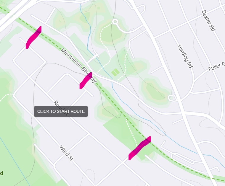
That's Bedford St at bottom right, I-95 at top left. Notice the three pink highlights? Those are all cutovers from the bike path to the Reed section of town. As much fun as running up and down Bedford St might be, having these available makes a huge difference in opening up that section of town. For those of us further north and east, it adds a ton of options for adding just a bit more distance and variety.
I don't think I've used the easternmost one (Garfield) at all, and I've only used the westernmost one (Avon) a few times. But the one in between (Laurel/Essex) I use a lot. Besides providing access to the Reed area on one side, it also provides access to Valley St on the other. (Warning: Valley runs pretty steeply downhill from east to west.) There's also a path even further north to the circle at Cider Mill. If your way out/home lies more on Simonds or Williams than Hancock or Ledgelawn, that might be handy.
5. Far North
Don't worry, Estabrook folks. I haven't forgotten that you're part of Lexington too.
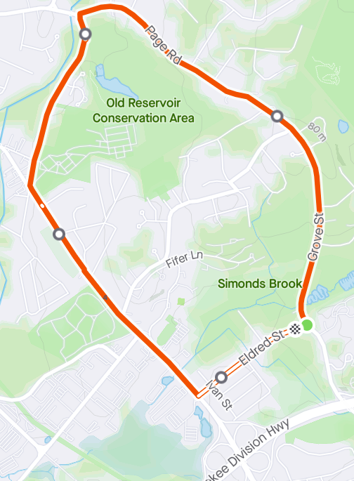
This is just a bit north of everything else so far - Bedford St I-95 interchange at the bottom, with Wyman and Williams forming the bottom of Manor Hill in the corner. Up at the top you'd hit Route 62 if you didn't turn south onto Shawsheen toward the cemetery - and the Citgo, and the McDonalds, and Bedford House of Beef (try the gyros), etc. This route is about 3.6 miles as shown, but that's only because I left out the "approach" from my house. Remember what I said earlier about having to come back the same way if you cross I-95? This is an example. You really don't want to cross I-95 on Bedford St, so Eldred is the absolute key here. It brings you back to that join point, then you can retrace your steps to wherever you started.
So, that stretch of Grove St from I-95/Robinson up to Volunteer Way or Carriage Drive? It's a bit of a beast. Much of it is 5% grade or worse, and it's pretty steady but it just keeps going. There's a solid argument for doing this route the other way around, especially since Eldred also runs uphill from west to east at the end, but this is the way I usually do it and the reason is our last map.
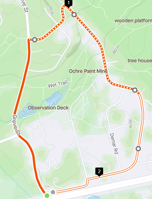
This is how you bail out if you're utterly sick of Grove St before you get to the top. You turn right on Gould (or Dewey), then onto Turning Mill around the east side. That dumps you straight onto Robinson Rd (parallel to I-95) and back to Grove - much lower down. Partridge Rd at the southeast corner might seem tempting, but it does add a bit more uphill.
You might also notice some strange words like "wooden platform" and "tree house" at the top right, and "wet trail" in the middle. Those are the Burlington Landlocked Forest and the Paint Rock pool area respectively. They're just far enough that I haven't explored them yet, but some friends who grew up in that part of town have mentioned them fondly. Maybe this fall I'll map them out.
6. Closing Remarks
There are - of course! - many other routes I've left out. I haven't covered the things actually on Manor Hill, or south to Ledgelawn, because they don't have a lot of "hidden secrets" you wouldn't see on a map. (OK, yeah, there's a cool little cut-through from the north end of Blake to Williams.) I didn't cover the far-east route on Muller and Wheeler. I didn't cover the far-west route along Hartwell and Wood St. I could write a whole article just as long as this one about the south side of town where I lived for almost twenty years. But this should give you a good starting set of ideas to get around the disconnected and hilly mess that is north Lexington. Enjoy!